
History
Historical sources to be collected and analysed were chosen based on two basic criteria.
1. Sources have to contain relevant and compatible information. Threshold resolution levels were set for all areas of interest, and sources that can provide the required details were sought. These levels were established so that the information remains compatible with palaeoecological and ecological data but still available in larger quantities. For management, we record five basic categories: coppice, coppice-with-standards, pollarding, high-forest and non-intervention. We also collect data on various human activities (e.g. pasturing, pannage, litter raking, hay cutting etc). For tree species, common terms (such as oak, beech, elm etc.) are considered sufficient. These in most cases refer to genera, and in exceptional cases (such as beech, Fagus sylvatica) to species. For woodland cover, both quantitative data (hectares of woodland) and qualitative data (presence or absence of woodland) are considered. The latter option was included to broaden temporal coverage. While it does not provide the same amount of precision as acreages, it is, when available in larger numbers, a good indicator of landscape openness at large.
2. Sources have to be available in larger quantities. Such sources were chosen that contain large amounts of data produced with the same administrative methods, which are therefore easily comparable.
The following sources are used in the database:
Medieval charters
Starting from the 11th century, these documents comprise mostly donations and occasionally include information on woodland presence, management, tree composition and individual trees. We process the 15 volumes of Codex diplomaticus et epistolaris Moraviae.
Zemské desky (Ger. Landtafeln)
Kept from 1348 until the 19th century, these books recorded changes in land ownership including woodland.
Urbaria (sing. urbarium)
Urbaria are conscriptions of all incomes from an estate. Information on woodlands includes dominant tree species, management and woodland sizes. Urbaria were compiled in Moravia from the 15th to the 19th centuries. We process all existing 883 Moravian urbaria.
Cadastres
Cadastres are nationwide surveys of land-use types and tenure for taxation. Different land-uses were given different values, based on which the owner’s taxes were established. The Josephian cadastre, prepared in the late 1780s, contains basic information about woodland size, tree species composition and management for every settlement. The Stable cadastre (mid-19th century) is an even more detailed and complicated survey, which records the tree species composition, size and management of each wood in every cadastre.
Forestry management plans
These are detailed surveys produced as part of modern forestry since ca. 1800. They contain information on the name, size and position of each woodlot, as well as on tree composition and forest structure, supplemented by present and planned management.
Records of settlement expansion
As part of their historical geographical lexicon, L. Hosák and R. Šrámek collected data on the first mention of every settlement in Moravia. We feed this data into the geodatabase to get a picture of the expansion of the settlement area since the Middle Ages.
Archaeological data
For the reconstruction and modelling of settlement dynamics in Moravia from the Mesolithic–Neolithic transition (ca. 7000 BC) until the 13th century AD we collect all available records of human activities (living, burying, mining, etc.) in various forms of community areas (settlement, burial ground, quarry, pottery workshop, hillfort, etc). As there is no centralized robust database of archaeological record in the study region, we use specialized databases for archaeological heritage management (SAS - State Archaeological List, MEGALIT) and we combine these with data from published papers and records of past archaeological research kept at Archives of the Archaeological Institute of the Czech Academy of Sciences in Brno.
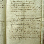
-

- Account book for Moravský Krumlov from 1650 AD
-

- Description of coppice woodlands around Mikulov in 1414
-
- Description of woodlands in the urbarium of the Mikulov estate in 1629 AD
-

- Forest management plan of Hodonínský Dubrava from 1851 AD
-

- Sample record in the archaeological database
-

- Sample record in the historical database
-

- The structure of the archaeological database
-

- The structure of the historical database